
OfflineMaps offers you to access a wide range of maps!
No advertisements ~ No data sharing & monetization ~ No analytics ~ No third party libraries
Bored to wait for maps to display? Use All-In-One OfflineMaps! Once displayed, maps are stored and remain available, quickly, even with no network access .
• Want more than just roads on your maps? You will find what you need here;
• Used to go to places with poor network coverage? Everything will stay available;
• Used to go abroad? You won't be lost anymore;
• Have a data allowance limit? It will reduce your usage.
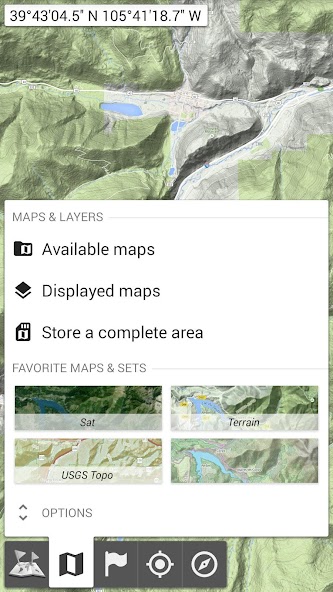
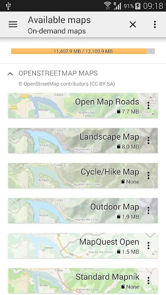
★★ Maps ★★
古典的なロードマップ、地形マップ、空中(衛星)マップ、任意のマップに追加できるさまざまなレイヤーなど、多くのマップが利用可能です。OpenStreetMap(Roads、Topo)、USGS National Map(Hi-Res Topo、Aerial Imagery)、Worldwide Soviet Topo Mapsなど。
• All maps can be stacked in layers, with precise opacity control;
• Select and store large areas in few clicks;
• Stored space is clear and can be easily deleted.
★★ Display, store and retrieve unlimited placemarks ★★
You can add various items on the map such as waypoints, icons, routes, areas and tracks.
You can easily manage them using the powerful SD-Card Placemarks Explorer.
★★ On-map GPS Location & Orientation ★★
実際の位置と方向はマップに明確に表示されます。これは、実際の方向に合わせて回転できます(デバイス機能に依存します)。
Easy turn on/off to save battery.
And also:
• Metric, imperial and hybrid distance units;
•GPS緯度/経度およびグリッド座標形式(UTM、MGRS、USNG、OSGBグリッド、アイリッシュグリッド、スイスグリッド、ランバートグリッド、DFCIグリッド、QTHメイデンヘッドロケーターシステム、…);
• Ability to import hundreds of coordinate formats from https://www.spatialreference.org;
• On-map grids display;
• Full screen map view;
• Multi-touch zoom;
• …
★★ Need more? ★★
あなたが本当の冒険家なら、 AlpineQuest Off-Road Explorerを試してください。オールインワンのオフラインマップに基づく完全な屋外ソリューション、強力なGPSトラックレコーダーなど:https://www.alpinequest.net/google-play

January 22, 2026
January 22, 2026
January 22, 2026
January 22, 2026
January 21, 2026
January 21, 2026
January 21, 2026
January 20, 2026
January 20, 2026
January 20, 2026
 ダウンロード APK(50MB)